

Chapter 17: Bikepacking the Altravesur-Niguelas to Pampaneira
- Angela Hart
- May 26, 2019
- 10 min read
Updated: May 27, 2023
6th-7th May 2019
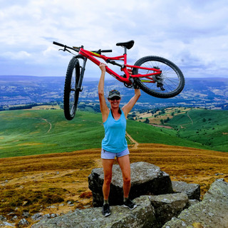
You can see my YouTube on this ride here
El Secreto de Olivo hotel in Nigϋelas price includes breakfast, I only had a couple of slices of toast, so thought it would be OK to nick a couple of pieces of fruit for later! At breakfast there was a group of around eight guys from the UK that were on a road-cycling holiday, based at the hotel, going for different rides each day. There was more in their group, 17 in total, the others staying at a rented villa, a pretty big group!
It was my earliest start riding to date, well except for my forced early start after the El Burgo fiasco! 8am and there was no problems with getting lost it was a steep ride down out of town, across the riverbed, then steeply up onto the camino. I could see the mountain I needed to cross, it looked quite daunting, and I knew this was the lower of the two I’d need to cross to get to my destination of Pampaneira.

The camino was at first surfaced, it was much steeper than other caminos for the first two kilometres or so, then it became a little easier, but was always up. The road was not only steep but switch-backed as well, so it seemed lots of pushing but I soon had climbed much higher than Nigϋelas and I started checking the altitude on my map to try and encourage myself or will myself up to the 1900 metres.

I’d decided I needed to control my hydration and nutrition better, to stop this continual cycle of dehydration and sunstroke. I vowed to stop every hour for ten minutes to re-fuel and cool down, this lasted once, at quarter past nine, where I stopped at what would have been the most fabulous wild-camping spot. The next stop was half eleven and then God knows when, that didn’t last long did it!
The scenery was pretty, rugged and green with trees, shrubs and flowers, interspersed with rocky outcrops. And soon mountains in all directions, with a large plain beyond Nigϋelas and some distance to the mountains in that direction.

Pushing, pushing, pushing. At 1500 metres someone had claimed a parcel of land and had built a cortijo and fenced his parcel off meticulously! It was a beautiful location, looking down over the towns on the valley floor, and up at the higher mountains. Strangely his house had a pitched roof, usually they are of flat roofs.
At 1700 metres I came across a welcome Fuente, where I replenished my water, not bothering to filter it at this altitude. Although really I should as later I’d stop at a waterfall where there was cow poo in the stream, and this was around the same altitude, so it’s not always safe. In fact, I drink out of the town fuentes without filtering, and realise I probably shouldn’t.

So I’d ridden/pushed-up the mountain visible from Nigϋelas, to 1200 metres then along the ridgeline of the higher peak behind it to around 1400 metres, Then down a 100 metres, upto 1700.


This dirt camino runs around the edge of the Sierra Nevada, on the map it looks like it goes up and down, when in fact, because each hill or hump of the mountain sticks out, you are running quite level, perhaps falling and rising a couple of hundred metres in elevation once you’ve done the big push up to it. It’s a nice ride, very hot in the sun with little shade, but it has some fabulous views.
I’m not sure I went the right way at a junction, it kind of forks off, I took the left fork but think I should have taken the right. They end up in the same place though.
The route goes down to a river valley, the gravel camino gives way to a grassy, little-used camino that is quite steep and good fun. I was running out of brakes on this section, it was pretty fast. The camino suddenly ends and becomes a grassy meadow, I had obviously missed my turning. I had lost my Google maps and hence the Altravesur route, so I had no idea where to go. I had started to go down through the meadow and realised this isn’t a trail!
I decided to retrace my steps, coming to a steep, rocky, switch-backed singletrack on my right. The signpost indicated it wasn’t suitable for bikes. This was some sort of walking route and it seemed to incorporate, what I thought was a cycling route, named Circuit de Tello. All a bit confusing. I notice on the map that there is a refugio down in this river valley, what a shame I didn’t find that. I seriously need to get better at looking at the map and planning.
I made my way down this trail to the fast running mountain river, Rio Lanjaron I believe, where I replenished my water again. There are signposts to Tello, which I think must have been a smattering of random houses over quite a large area. Pushing back up from the ravine I found some signposts, but none were listing the direction I thought I needed to go, I kept going the way I thought and found a GR7 post, which after some time led to a camino.
This camino continues up to 1900 metres, then runs along the side of the mountain, sometimes on the level, sometimes uphill but never a good downhill. I was exhausted, it was getting on for 7pm by now.
Water wasn't a problem, there was access to many acequias.
I’d met a couple of young German hikers in Nigϋelas the night before, and met them again on this camino, they were setting up camp in, what they thought was the garden of an empty forester’s house. They invited me to camp there too, but I didn’t fancy it, it didn’t look abandoned and I didn’t want waking up in the night to get thrown off the landI can’t find it on the map, so still have no idea what the building was, but I’m pretty sure it wasn’t a refuge. I continued on, stopping four kilometres farther on, at a recreation area but the trees were so thick and tall that no light was getting through. There were some abandoned buildings there, a café and toilets in fact.
I continued on about a kilometre or so and saw, off-camino, down a turning to my right, what looked like an abandoned nave. The grass was grown up around it, and around the doors. I deliberated as to whether I should camp there, it was half seven by now and I was exhausted. So I decided, Yes!

There was water close-by which was a bonus. I had a great night’s sleep, and wasn’t disturbed at all, I didn’t hear or see a human being or a car the whole time.


On Tuesday morning, after some breakfast, I packed up and set off. From here it was all downhill on a gravel camino. I rode the camino, fast downhill, all the way to the main mountain road. I love these camino downhills, they’re bumpy and twisty, and usually running along the side of the mountain with a huge drop down to one side.
When I got to the road, I checked my map and I realised I should have turned off around half a kilometre back, dammit! So I spent half an hour pushing back up, now in the hot sunshine, and took the turning I missed. It was chained off, but loose enough to lift the chain over the bike.Meta and Robert who had ridden through here the week previous, had said there was a turning not to take, of course I forgot about this! I continued along the track, there was a shack on the right with a lot of litter, and around six cats which scarpered as I rode near.
Eventually the double track peters out to single track, then just grass. That’s when I remembered what Robert had said, this was what he was talking about. He had said take the main road as this was just grassland and difficult to traverse! Dammit again! No matter, it had been all uphill from the road to the camino, and from the camino to this track, so it didn’t take long to whizz back down and was a good ride! I turned left onto the mountain road, heading for Pampaneira that I could see high up to my right across a ravine, so I knew it would be quite a climb.
On arriving in the town, I saw an inviting looking restaurant, as I drank my coke I noticed that it was also a hostal. Although only around midday I decided to enquire if I could stay there as I needed to re-stock my camping provisions. It was a little more expensive than I wanted, nevertheless I booked the room which was immediately vacant.

I set about doing my washing, hanging my clothes from my bungees across the window shutters. I went off to explore the town and get my shopping, only to discover there wasn’t a supermarket of any sort in Pampaneira, the most they had was a Panaderia that had some essentials alas no camp friendly foods.
I decided I needed to protect myself from the blazing sun better, so went looking for a more suitable hat than a baseball cap, eventually settling on a Panama hat, that actually fitted me. I have terrible problems with hats, I have a stupidly small head! But this was perfect. I also bought some Myrrh incense sticks to use in my tent as Robert and Meta had said there was quite a lot of mozzies in the Sierra Nevada.
So, I’d have to get the bus to the higher villages of Capileira or Trevélez to get my shopping but the daily bus had already gone, so I decided to book the room for the next night too, which would give me all day tomorrow to get the bus.
Bay was only allowed in the Restaurant, not my room, so I locked him to the radiator and hoped for the best. Pampaneira, along with Bubión, Capileira and Trevélez are popular towns for tourists. Coach-loads of them are dropped off in the pueblos each day. These tourists are the main source of income here, with many shops selling souvenirs, trinkets and local produce, along with many café bars and restaurants. These are also popular towns in which to base a Hiking or Biking holiday.
I had an embarrassing moment, when I returned to my room after my attempt at shopping, I noticed my spongebob cycling pants had fallen off my bungee. Being on the first floor I couldn’t retrieve them, so I went outside to see if I could get them but they had fallen into a narrow drainage alleyway that was fenced off. I told the grumpy waiter what had happened, and he was less grumpy at sorting this out, he got a man from the bar to climb over the high railings to retrieve my sopping wet pants!
When I say grumpy waiter, I mean the one that waits the tables a little later in the day. The man that’s there early is really friendly and kind. This other guy just seems bad tempered, and not just with me!
I had a rough idea where the bus-stop was, but on getting there a man told me the bus stopped way up the hill, I thought damn I’m going to miss it at this rate, so rushed up the hill, only to be told it was where I thought it was in the first place. I was getting hot and bothered by now but made it back to the bus-stop in time.


Opposite the bus-stop was a coach park, yes a coach park in this tiny pueblo, and four coaches were parked up after dropping off the tourists, some Spanish and some French. You can imagine how busy the town gets! It’s impossible to take a nice photo, there’s too many people around!
Whilst at the bus-stop a young guy came riding by with luggage on his bike, so I stopped him and asked him about his route. He was from Dublin, I forget where he flew into, but he was heading for Almeria airport where he had a flight booked. His riding was on the road, not on the caminos, so a different route to me.
I should have just got the bus to the next village of Bubión as they have all that I need, but I decided that I may as well go to Trevélez as it was bigger and assumed therefore it would be better! This was a mistake. The road to the other villages climbs steeply out of Pampaneira, but in no time we was in Bubión. Then onto Capileira, once in Capileira the bus turns around and goes all the way back as Capileira is up a dead end! Then it goes on to Trevélez, reputed to be the highest town in mainland Spain at nearly 1500 metres, and famous for its cured ham.
Everywhere you go around these parts you find a pig’s hind quarters hanging up, pretty gruesome! Anyway the bus takes nearly an hour to get to Trevélez, and waits there until 4pm, when it returns to Granada, passing through Pampaneira.
Trevélez has lower, middle and upper areas, the bus drops you in the lower area, all I could find there, shopwise, was tourist shops, ham shops and breadshops. On asking if there was any supermarkets I was told no! Dammit, should have researched better! And time was moving on, it was around one o’clock by now and shops shut at 2pm for siesta. I decided to walk higher, and in the middle barrio, there was a couple of supermarkets and ferreterias.
The supermarkets weren’t greatly stocked, so I improvised with my camping provisions. The first ferreteria didn’t have any butane, it was more building materials. On asking in the one opposite, the woman said no we don’t have butane. Argh. So I went looking for another ferreteria, to no avail. I’d gone high up by now, and was hot and bothered. On my way down I went back into the second ferreteria and hunted around a bit and found they did have butane, I was happy and annoyed at the same time, all the rushing around I’d done and they had it all the time. The sales assistant should learn her products, dumbass.
Anyway, shops were shutting, so I found a lovely little restaurant terrace and parked myself down for some lunch. Whilst I was there two guys stopped for lunch, they were driving one of those cars that map the roads for Google and Apple. We got chatting, Dominic is from Ireland, and Adam is from Spain, he drives and Dominic is the technical wizard, I think. Very interesting job me thinks! I’d like to do that!
I had a lazy lunch as I had time to kill until the bus left at 4pm. I wanted a map of the Sierra Nevada, a proper hiking map, the cheapest of exactly the same map I found was twelve euros, in one shop it was eighteen euros!! What a ripoff!
One thing I noticed on the bus, was that I was feeling a little queasy, which ceased once I’d gotten off the bus. That’s the first time I’d experienced travel sickness, yuk not nice. It was the same on the way back!
On Wednesday evening, when I was back from Trevélez, the waiter reminded me that the Hostal, Restaurant and Bar were closed on Thursday and that I needed to pay for my room and move my bike out of the restaurant. I’m not sure why they didn’t let me put my bike in my room in the first place! As that’s where I put it for Wednesday night!
Hasta luego mis amigos

Comments