

Mount Lawson State Park - Camp - Bushwalk - Bike Ride
- Angela Hart
- Dec 18, 2022
- 8 min read
Updated: Dec 24, 2022
Cold and rainy weather here in Albury, New South Wales, Australia, has been the norm for the past ten months. With working full time, doing life and carrying out Grandma duties I'm left with little time for leisure activities. Unfortunately the coincidence of sunshine days and free time are very rare.
After Granny duties until 5pm last Saturday, I realised that if I want to get out more, I needed to change my mindset, and break the chain of thinking that I have to go on a weekend trip on a Friday night or Saturday morning. So decision made, at 5:30pm, I was to go camping that night!
Check out my video of this trip here
Mount Granya State Park and its neighbouring Mount Lawson State Park have been on my radar for a short bikepacking trip for a while. I've already checked out Granya, so I thought I'd go to Mount Lawson this weekend, with Granya as a backup, should it be busy or not suitable.
Very stupidly, in my rush to pack my camping gear, hiking gear, cycling gear, food etc. I forgot to print out and download detailed maps of Mount Lawson State Park, which caused a bit of a headache later in the trip.
Setting off at 7pm in the evening sun gave me such a buzz, the freedom and anticipation of what will happen this night was just what I needed, it's a bit like driving home for Christmas, there's something so special about it.

It's a beautiful drive, over the Bethanga Bridge, crossing Lake Hume, then alongside the swollen Murray River, with the sun setting behind me. Not knowing what to expect, or whether there was even a campsite at all, I had no time to meander.
I wasn't sure of the exact layout of the park and the campsites, there wasn't time to investigate properly. My first destination was going to be the Kurrajongs, shown on Google Maps as a campsite, that is situated on the north-most left hand corner of the park.

What a relief, driving into the Kurrajongs, it was clear that I'd be able to camp here, whether legally or not! There wasn't any sign of other campers, which is always preferable to a hermit like myself. I slowly drove along the fire-road that runs through a sparse bushland into the site. A drop-toilet can be found approximately 300 metres in, on the right, then at 450 metres the road ends in a turning circle, with picnic table and firepit. I couldn't see a decent camp spot at the firepit area so I headed back the way I'd came. There's plenty of flat ground and some shorter brush, I'm allergic to grass, so the shorter the better for me. I parked up in a more like meadow part of the bush, on the right next to a clump of gum trees, that I thought would make a great anchor for my tarp.

I'd packed my car quickly and messily, so I was very disorganised during camp setup but managed to get it done before darkness fell. Two things I hadn't expected was the amount of ants and mosquitoes! The 15 to 20mm long ants were relentless, if I stood still for too long they'd be crawling up me. The mozzies were tiny, which made me think they'd be quite harmless, how wrong was I! I'd changed into long sleeves and leggings when I saw just how many were about and thought that as they were so small that I'd be OK, alas not.

Once zipped up inside my tent, my Marmot Fortress this time, I was safe from the insects, well except for those that got in whilst I setup. I regularly found an ant for the next few hours and I spent quite a bit of time swatting mozzies. I'd lit an incense stick inside my tent, I'm pretty sure that the smoke, pungent aroma or both, deter the insects.
I settled down to sleep around 10pm, but was awoken quite often by wildlife scurrying around outside my tent and by the fact that I had only brought my Z-lite foam mattress, being a side-sleeper, it isn't comfortable on my hips at all.
I opened the tent a few times to see what was making the noise, and always it was a possum, well that's what I think is anyway! Around 1am I was woken by a deep throaty growling, a bit like a cats growl but louder. I'd shout 'go away' and it would growl, I'd shout go away and it would growl, this went on around ten times, until I drifted off to sleep again. I don't know what it was and wasn't going to be going outside to check! I was soon awoken by the possums again so decided to go outside and take some photos. I'm so glad I did, there was a beautiful night sky, with stars and a bright three-quarters moon. I wish I had a video camera that could capture the night sky, it was so beautiful.


I also got to see a baby and mumma possum, they really didn't seem bothered I was so close to them, and I caught some footage.

Waking at around 6am Sunday morning, I had a coffee or two then set-off on my bike to explore the Kurrajongs. This didn't take long! The fire road that goes off to the left just goes in a short loop and back to the turning circle and the campsite. This is where having no map or accurate download was hurting me. I knew you could get into Mount Lawson from the East, West and South but didn't know exactly where, and I don't think the offline Google maps gives you the same view that it does in a browser.
The mozzies were up early as well, as were the ants.
Guess which nincompoop hadn't checked the weather forecast! The blue sky suddenly turned dark, and some gentle rain fell but not much became of it, and a cloudy blue sky eventually returned.
Checking out the information board opposite my camp, I found some info and a map on the Flaggy Creek Walking Track. There was a short out-and-back walk to Valley View approximately 3kms return, and a long out and back on the same track, 14 KMS return.


I decided to do the short hike, luckily I'd remembered my gaiters this time, so I had a small amount of protection against snake bites. Setting off, you come to a Visitor Intention Book, which is the first time I've seen a book on an Australian trail. I've seen them on YouTube videos in the USA, so it was exciting to make my first entry in a hike book!
Heading out, it's mostly an uphill, well-marked trail, with lots of switch backs and boulders, through a rocky bushland. In no time at all you've climbed quite a way up and are rewarded with some beautiful views of the Murray Valley and surrounding peaks.

Not long into the trail is this lovely spot for a picnic, although I'm not sure on the ant situation. There are ants everywhere here, many a time they were crawling up my legs, and at times I just couldn't get away from them.

The ground is quite loose, and there's some minor rocks to walk up and over but nothing too strenuous. You eventually come to the Valley View sign that is in front of a large boulder cluster. There has been some human intervention to make it easier to climb the boulder, enabling you to get atop and have a wonderful view of the Murray Valley and surrounding hills. I wouldn't recommend clambering up the boulder it if it's wet, as there is no protection from falling, I wouldn't be taking minors up there either. In fact, I thought it a bit foolish of me to climb up it, since I hadn't told anyone where I was going, had no phone signal and there was no one around to help should I have injured myself.

I nearly forgot to check for a phone signal, remembering just below the top of Valley View, I managed to download a fire-road loop in Mount Lawson State Park in the Komoot app.


I'd recommend hiking poles, particularly useful on the way down, if you're a bit wobbly like me! The ground is loose, not too steep but certainly downhill on the way back. I didn't take note of the time I left for the hike, but I'm guessing the round trip was perhaps 3 hours, probably an hour or so was filming and taking photos!


On returning to my tent, around 11am, I thought I'd cook something to eat but again the ants were relentless, so I had a quick cup of soup and started packing up. I'd skipped breakfast, so skipping lunch was later to have me over. With hindsight, what I should have done was rest up, make lunch then pack-up, my day would have been that much more successful should I have done that.
The ants really were problematic while packing up, but it didn't take long and I set off around midday to take a look further East down the Murray River Road/Highway. I could see that the may be a way into Mount Lawson State Park from the East, which would mean turning right some way after the park, then right again.

I took a quick look at Burrowye Reserve Camping area which was off the Murray River Road/Highway, as I was driving out East, it's a nice little riverside spot.

I drove 28 kilometers East/South East to try and find a way in, with not seeing any opening on Google maps, I decided to return West to find the route I downloaded on Komoot.
The entrance to the Flaggy Creek Track is through a farm entrance, it took me three goes to actually select the right part of the farm yard to pass on through, it's the right-most track from what I remember. Driving through gates, over cattle grids and meadowland, after around three kilometers you're into the woodland, it wasn't too gnarly, but it made me aware that really with no phone signal, no one knowing where I am and driving a two wheel drive car, that I should think about getting a 4x4, sooner rather than later.
I parked up in a little cutting and got ready for a ride. On seeing someone racing out of the forest on an ATV, at first I was a little worried, in case this actually was private land, then it became a complete pleasure as the lady racing down the hill stopped to say hello. I didn't get her name, she lives at the farm on the entrance to the track. We spent ten minutes chatting, giving me lots of helpful information which was so very nice of her. "Straight up the hill for 2kms and keep an eye out on the left-hand side of the track", she's marked a cutting through to the waterfall and rockpools that you can cool off in.

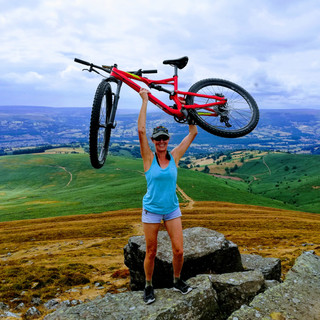
It was hot and sunny when I set off on Stumpy (my bike) to find the waterfall. As I was riding, then pushing up the steeper parts of the track, I was getting increasingly tired. It was only around two o'clock, if I'd have thought about it, I'd have taken a nap in the car, had something to eat, then set off. As it was, I barely slept the night before, I didn't have breakfast, and I'd only had some soup for lunch. I very soon 'bonked', which is where you have burnt all your energy reserves and there's nothing left. Feeling exhausted, after around 1km, I had to turn around and ride back down, which I had to do slowly as I'd forgotten my crash hat! Argh what a disaster, and what a pity I didn't just rest up, eat something on my return, then try for the waterfall again. Never mind, I'd had a good micro-camping adventure, a nice hike and learned where the waterfall was. I came away with some lessons, and also on my legs, 24 mozzie/ant bites, 9 of those on my bum!!
Homeward bound, the skies darkened again, with some moderate rain falling. I was a little disappointed but promised myself I will return to find the waterfall another day!
I again learnt lessons from this, and they are:
Always check the weather forecast
Download some route variations and a map of the area I'm going
Take time to fuel myself
Take time to rest up when required
Tell someone where I'm going before leaving home
I need a 4x4 vehicle
Make improvements to my insect repellant situation!


Comments